
Black Sea Türkiye
UNESCO Heritage Sites and Routes
City of Safranbolu, Karabük
UNESCO World Heritage Site 1994
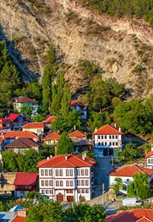
Safranbolu, known as Saframpolis in antiquity, was a major city in the ancient district of Paphlagonia. Safranbolu is situated in the Western Black Sea Region, 230 km north of Ankara and 10 km from Karabük. Almost nothing from its ancient period has survived. Being an important caravan station on the main East–West trade route, the city became the financial center of the area. Safranbolu consists of three historic areas: the marketplace area of the inner city, known as Çukur; the area of Kıranköy; and Bağlar, the Vineyards. Çukur is located in the lower part of the town as the name Çukur (pit) suggests and is surrounded by two rivers. The marketplace is surrounded by traditional houses and the workshops of craftsmen. The city center represents a typical Anatolian town center, a çarşı (bazaar, open market area). Kıranköy used to be a non-Muslim district and in the typical architectural style of the time, artisans and tradesmen lived above their shops. The houses here were built using stone, while the houses in Çukur were wooden.
The Bağlar (Vineyards) area consists of mostly detached houses set within large gardens. This district on the northwest slope of the city, looking to the south, was the city’s summer resort.
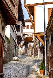
The streets in Safranbolu are mostly stone-paved, and the older houses are half-timbered with the spaces between the timbers filled using various building materials. There are no windows looking to the street, so that stone walls resemble extensions of garden walls. The rooms served different purposes and were connected with halls called “sofa,” which formed an important element of the house.
The city of Safranbolu is a typical Ottoman city, with typical buildings and streets, and played a key role in the caravan trade over many centuries. The settlement developed as a trading center after the Turkish conquest in the 11th century, and by the 13th century, it had become an important caravan station. The Old Mosque, Old Bath, and the Süleyman Pasha Medrese were built in 1322.
Hattusa: The Hittite Capital, Çorum
UNESCO World Heritage Site 1986
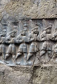
Hattusa, or modern-day Boğazkale, is 85 km from Çorum, in a fertile valley in Central Anatolia. It was the capital of the Hittites during the second millennium BC. The site of the ancient city with the ruins of temples and palaces, the monumental sculptures, and the enormous fortification walls with ceremonial gates and tunnels attests to the fact that this was once the home of a great empire. Much has been learned about the religion of the empire’s people by studying the line of gods and goddesses carved on the walls of the open-air rock sanctuary at Yazilikaya. The relief of the Hittite pantheon constitutes one of the best examples of Hittite monumental relief sculpture in situ. The excavations have revealed that the area was inhabited as early as the 5th millennium. The thousands of Hittite tablets that came to light changed what was known about this period of time. When the Hittite texts were first deciphered, scientists realized that they belonged to an important empire of the 2nd millennium which had been unknown up until then - an empire that could compete with the Egyptian and Assyro-Babylonian kingdoms. The Hittites dominated the 2nd millennium, went as far as Kadesh (Syria), and confronted the Egyptians there. As a result, the first written peace treaty of the world appeared between the Hittites and the Egyptians. Another interesting revelation was that almost all of the Hittite gods are earlier versions of the Greek gods. For instance, the weather god Teshup became the Greek god Zeus and Teshup’s consort Hebat (or Hepatu) became the later Hera. The Hittite texts also offered points of reference for the Egyptian texts. The city seems to have flourished especially during the 14th and 13th centuries BC, and most of the monumental buildings we see today are from this period. Like Troy, and almost all Bronze Age settlements of Anatolia, Hattusa was abandoned and never recovered its prosperity after the 12th century BC.
Today, visitors can visit Hattusa in two parts: Yazilikaya, the open-air rock sanctuary of the Hittites, and the city itself. The Yazılıkaya rock sanctuary is unique and the biggest open-air sanctuary of this period. As you enter the sanctuary, you will see the foundations of a building complex that used to be the offices in charge of maintaining the sanctuary. As you continue, reliefs on rock surfaces will appear. On the left, there are all the male gods, and on the right, the female goddesses. All are approaching the main scene, where Teshup and his wife Hebat, standing on mountain lions, are meeting. Immediately on the far-right side, there is a relief of the Hittite King Tudhaliya, who was in charge of the construction of this sanctuary. In the second room, there are reliefs of the 12 Hittite gods of the underworld; Nergal, the “Sword God”; and King Tudhaliya being embraced by god Sharruma, son of Teshup and Hebat. Perhaps this room has a connection to Tudhaliya’s funeral.
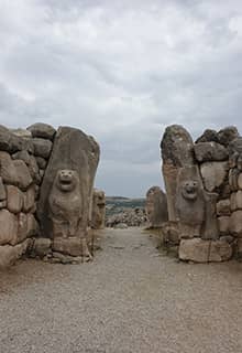
Other important monuments in Hattusa are the Great Temple, the Lion’s Gate, the Sphinx Gate, the King’s Gate, Yerkapı (meaning “the gate in the ground” in Turkish) rampart and tunnel, burial chambers, the Phrygian Castle, and the well-reconstructed fortifications. A visit to both Boğazkale and Çorum Museums will add a lot to your visit.
Sümela Monastery (The Monastery of the Virgin Mary), Trabzon
UNESCO World Heritage Tentative List 2020
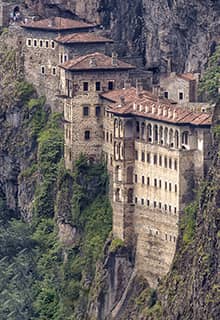
Sümela Monastery, a Greek Orthodox monastery dedicated to the Virgin Mary, is located 35 km south of Trabzon and 8 km from the town of Maçka. The monastery’s construction on the Pontic Mountains began in AD 385 and continued up to the 19th century. According to one theory, it was founded by the Athenian monks Barnabas and his nephew Sophronios. The monastery became famous for an icon of the Virgin Mary, believed to have been painted by the Apostle Luke. Recent conservation and preservation work have made it much easier to visit this magnificent monastery. The Altındere National Park, where the monastery is located, adds a lot to the beauty of the scenery.
Mahmut Bey Mosque, Kastamonu
UNESCO World Heritage Tentative List 2014
The Mahmut Bey Mosque, which dates back to the 14th century, is located in the historical village of Kasaba,18 km outside of Kastamonu. It was built by Mahmut Bey in 1366, during the reign of the Candarid Beylik (Candaroğulları Beyliği, also known as the Isfendiyarids). The Mahmut Bey Mosque is one of the very few wooden mosques that have survived to our days from this early period. The mosque is unique in so far as no cement was used in its construction except for the mihrab (pulpit). The roof was also constructed without using any metal element. As a result, it is also known as “Çivisiz cami,” meaning the "mosque without a nail." It is one of the first wood-columned and wood-roofed mosques in Anatolia.
Historic Guild Town of Mudurnu, Bolu
UNESCO World Heritage Tentative List 2015
Mudurnu is a small picturesque town in the Western Black Sea region, 50 km south of Bolu. The traditional houses are some of the finest surviving examples of Ottoman architecture and the craftsmen of the town still preserve the tradition of their 700-year-old guild. Mudurnu developed as a trading and military hub at the junction of major trade routes including the Silk Road, and emerged as an important cultural center of the Ahi Order in the Ottoman era. The Ahi Order was established in the early 13th century by Ahi Evren. It was a guild system and a merchants’ solidarity organization based on a philosophy of tolerance and the fair distribution of wealth. Mudurnu’s unique atmosphere, untouched nature, its long history, and the lifestyle of its locals that has been protected for hundreds of years, led to the inclusion of Mudurnu in the Cittaslow Network in 2015.
Mount Harşena and the Rock Tombs of the Pontic Kings, Amasya
UNESCO World Heritage Tentative List 2015
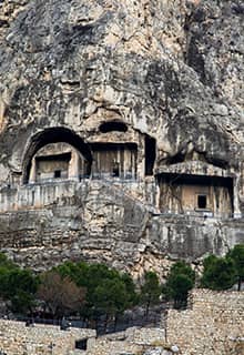
Some of the great rock-cut tombs of the ancient region of Paphlagonia are situated in Amasya, a picturesque town located on the shores of the Yeşilırmak River. The royal necropolis is located on the southern hillside of Mount Harşena, north of the city of Amasya and the Yeşilırmak. The monumental king tombs are carved in limestone rock formations and were created after Mithridates I (died 266 BC) who reigned during the 3rd century BC established the Kingdom of Pontus and made Amaseia (modern Amasya) the capital city. The tombs have always attracted attention and the area is also known as the "Valley of the Kings." Five king tombs are located here, and there are nine more inside the Amasya Fortress on the slope of Mount Harşena. The king rock-tombs, which contain large stone grave chambers inside, are among Anatolia’s largest rock-tombs and stand as outstanding examples of this tradition due to their monumental size – they reach 8 to 15 meters in height. As a result of the high position of the entrances to the grave-chambers, they are, in fact, accessible only by ladder.
Kızılırmak Delta Wetland and Bird Sanctuary, Samsun
UNESCO World Heritage Tentative List 2016
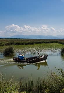
The Kızılırmak (lit. Red River) was called “Halys River” in ancient times. After Hattusa was made capital of the Hittites, the area encompassed by the bend of the Kızılırmak was considered the core of the Hittite Empire. The Kızılırmak is the longest river in Türkiye with a length of 1,355 km. It makes a huge curve meeting the Black Sea near Samsun. The Kızılırmak Delta Wetland is the biggest wetland in the Black Sea, and one of the country’s most important Ramsar sites. Ramsar sites are wetlands of international importance as defined by the Ramsar Convention on Wetlands of International Importance Especially as Waterfowl Habitat.
The Bridge of Justinian, Sakarya
UNESCO World Heritage Tentative List 2018
The Bridge of Justinian, or Sangarius Bridge, is situated about 5 km from Adapazarı, the capital of the province of Sakarya. It is a remarkably well-preserved Roman bridge built by the East Roman Emperor Justinian I who sought to improve communications between Constantinople and the eastern provinces. The bridge spans across the Sakarya River, which in antiquity was known as the Sangarius River. The bridge is an outstanding example of late Roman technical and architectural expertise.
Nature Park of Ballıca Cave, Tokat
UNESCO World Heritage Tentative List 2019
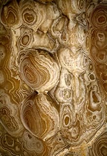
The Ballıca Cave is situated 6 km southeast of the town of Pazar in Tokat Province. It is a fossil cave, and its overall length is 70 m. The gallery, which leads to an open space with a pond, is the first section in the northeast-southwest direction. It consists of the “Stalactite and Stalagmite Hall” on the first level, and the “Fossil Hall” and “Bat Hall” on the second level. The “Magnificent Gallery” on the third floor is formed by the three adjoining halls: the “Mushroom Hall”, “Column Hall” and the “New Hall”. Common dwarf bat colonies live in different parts of the cave. The many colors in the cave are astonishing, and the filtered air is rich in oxygen.
Trading Posts and Fortifications on Genoese Trade Routes from the Mediterranean to the Black Sea
UNESCO World Heritage Tentative List 2020
The Genoese established several trading colonies and castles along the Mediterranean and the Black Sea between the 11th and 15th centuries. The castles at Yoros, Amasra, Sinope, Akçakoca, Foça are among some of the examples that can be seen today. The Galata Tower in İstanbul is perhaps the most famous Genoese castle of all. The castle of Çesme and the castle on the island of Güvercinada in Kuşadası are also in particularly good condition.

