Southeastern & Eastern Türkiye
UNESCO Heritage Sites and Routes
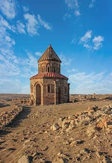
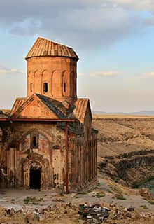
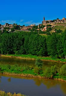
Archaeological Site of Ani, Kars
UNESCO World Heritage Site 2016
Ani is located 50 km east of Kars, at the Armenian border where the river Arpaçay forms a natural border between the two countries. The Arpaçay River contributes greatly to the Eastern Anatolian landscape. Ani was once a great metropolis, known as the "city of a thousand and one churches." It was the capital city of the Bagratid Kingdom of Armenia in the 10th century AD. Ani was situated on trade routes and grew to become a walled city of more than 100,000 residents by the 11th century. In the centuries that followed, Ani and the surrounding region were conquered by Byzantine emperors, Ottoman Turks, Georgians, and Russians who laid claim to the area, repeatedly attacking, and chasing out the residents. By AD 1300, Ani was in steep decline and by 1700, it was completely abandoned. Today, most of the churches are still standing to a sufficient height, and the streets, baths, an early mosque, and the great fortification walls are impressive. Thanks to its geographical location, the settlement in Ani has survived for almost 2,500 years. This city that was once one of the cultural, political, and commercial centers on the Silk Road, displays architecture that combines a variety of domestic, religious, and military structures, creating a vision of medieval urbanism built up over the centuries by successive Christian and Muslim dynasties.
Diyarbakır Fortress and Hevsel Gardens Cultural Landscape, Diyarbakır
UNESCO World Heritage Site 2015
Diyarbakır is the principal town of Eastern Türkiye and one of the country’s largest cities. The fortified city and its surrounding landscape have been an important multicultural center starting in the Hellenistic period, through to the Roman, Sassanid, Byzantine, Islamic, and Ottoman times and continuing to the present day. The city is a treasure of history and culture: ancient ruins, breathtaking architecture, flavorful dishes, famed exquisite gold and silver filigree work... Diyarbakır's extremely well-preserved fortifications and the Hevsel Gardens, the 700 hectares of cultivated, fertile lands near the Tigris River, make this city unique.
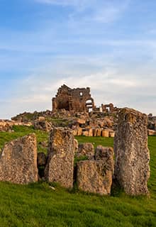
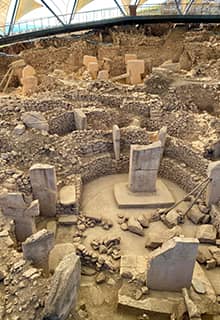
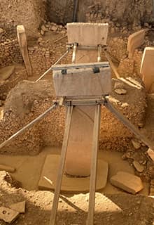
Göbeklitepe, Şanlıurfa
UNESCO World Heritage Site 2018
Göbeklitepe is perhaps the most known and discussed archaeological site of the last decade. It was discovered in the 1990s, and excavations have been ongoing since then. Göbeklitepe is approximately 20 km northeast of Şanlıurfa. The colossal anthropomorphic statues which date back to 11000-12000 BC are extraordinary for this period of humankind. Before Göbeklitepe, the history of the Neolithic period began around 9000 BC; the colossal statues and several of the reliefs on the statues are truly unique for this period. Considering the absence of metal tools, it is remarkable to consider that the statues were made using exclusively stone tools. Nothing similar from this period has ever been found. It is understood that Göbeklitepe was a kind of shrine, consisting of round rooms, each containing these colossal statues. According to scholars, this is a cult area where ancestral cult rituals were performed that were connected to death and the underworld. There are no ceramics or signs of any settlement here; however, the giant project that was carried out at Göbeklitepe points to a very sophisticated and organized society in close vicinity. Surprisingly, the Göbeklitepe shrines were not buried by natural causes, but on purpose by people who once lived here - the reason remains a mystery. Recent surveys in the area have revealed the presence of several other similar shrines/structures from the same period.
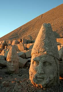
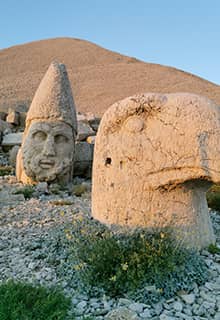
Nemrut Dağ, Adıyaman
UNESCO World Heritage Site 1987
Nemrut Dağ, or Mount Nemrut, is located approximately 50 km from Adıyaman. The mountain is the monumental tomb-sanctuary of King Antiochus I Theos of Commagene (69-34 BC), the most famous ruler of the Kingdom of Commagene. Antiochus, a late Hellenistic ruler, built this tomb-sanctuary for himself and decorated the whole area above the burial chamber with remarkable colossal statues. The scale and complexity of the design of this project was unequalled in the ancient world. Climbing to the summit, three different groups (east, north, and west) welcome you. The north tumulus was never finished; however, the terraces in the east and west all well-preserved. The east terrace contains the Gallery of Gods, the Gallery of Ancestors, and the altar. The main group of statues were the figures of five deities, representing the pantheon of the newly established religious cult. These figures were guarded by statues of a lion and an eagle, standing on both sides. The lion, the king of animals, represents earthly power, and the eagle, the herald of the gods, represents heavenly power. The western terrace also has almost the exact same statues. While the thrones on the east terrace are more intact, the heads of the sculptures on the west terrace are in better condition.
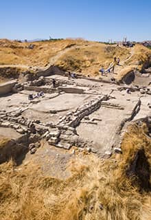
Archaeological Site of Arslantepe, Malatya
UNESCO World Heritage Site 2021
The Arslantepe archaeological site is at the heart of the fertile Malatya Plain, approximately 12 kilometers from the Euphrates. It is a 4-hectares and 30-meter-high tumulus (mound) dominating the plain. In the earliest phases of its history, in the Chalcolithic period around the 5th millennium, the settlement had close links to the Mesopotamian world, with which it shared many cultural features. But in the beginning of the Bronze Age, in the early third millennium BC, important changes took place at the site that halted the development of the Mesopotamian-type centralized system and reoriented Arslantepe's external relations toward eastern Anatolia and Transcaucasia (South Caucasus). A further radical change occurred in the second millennium BC, during the Hittite civilization, which exerted a strong influence on it. The unearthed king's palace is an open-air museum and the artifacts that have been excavated at the site are exhibited at the Malatya Archaeological Museum.
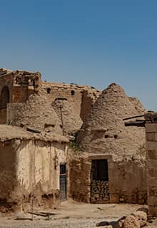
Harran and Sanliurfa, Sanliurfa
UNESCO World Heritage Tentative List 2000
Harran is situated 50 km south of Şanlıurfa, almost on the Syrian border. The earliest settlement at the site goes back to the 7th millennium. The earliest historical records of Harran go back to the Ebla tablets of the 3rd millennium BC, which were found in the palace archives of the ancient city of Ebla, in modern-day Syria. From these tablets, it is known that an early king of Harran married an Eblaite princess, Zugalum, who then became "queen of Harran," and whose name appears in a number of documents. Harran was always of strategic importance as it controlled the point where the road from Damascus joined the highway from Nineveh to Carchemish, and as a result it was regarded of considerable importance by the Assyrian kings. The city became a cult center for the moon god Sin in Assyrian times and through to Roman times. Harran is frequently mentioned in the Bible; Biblical Harran is where Abram (Abraham) and his family settled on their way to Canaan when they left the Ur of the Chaldeans. Harran was called “Carrhae” in the Roman period. In Roman times, it was the scene of the disastrous defeat of the Roman governor Marcus Licinius Crassus by the Parthians in 53 BC and of two later battles between the Emperor Galerius and the Persian King Narses. During the late 8th and 9th centuries, Harran was a center for translating works of astronomy, philosophy, natural sciences, and medicine from Greek to Syriac by Assyrians, and thence to Arabic, and bringing the knowledge of the classical world to civilization in the south. Later, Baghdad came to play this important role. Many important scholars of natural science, astronomy, and medicine originate from Harran. Today, most visitors admire the beehive-shaped local houses of this area which were made using mud bricks.
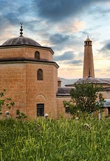
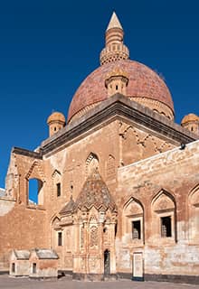
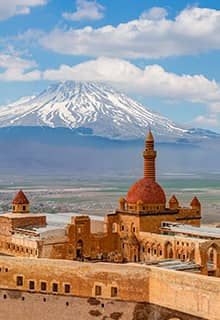
Ishak Pasha Palace, Ağri
UNESCO World Heritage Tentative List 2000
The Ishak Pasha Palace (İshak Paşa Sarayı in Turkish) is an outstanding example of a 17th-century Ottoman palace. The palace and administrative complex are located in the district of Doğubayazıt in the Ağrı Province. Construction was completed by İshak Pasha, who was to give his name to the palace and who became the Pasha of Çıldır from 1790 to 1791. According to the inscription on its door, the harem section of the palace was completed by İshak (Isaac) Pasha in 1784. The palace is one of the few examples of surviving historical Turkish palaces.
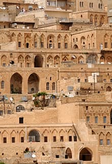
Mardin Cultural Landscape, Mardin
UNESCO World Heritage Tentative List 2000
Mardin is a wonderful city on the Upper Mesopotamia Plain in southeastern Türkiye, between the rivers Euphrates and Tigris. It was known as “Izalla” in the Late Bronze Age and was part of Assyria during the Assyrian and Neo-Assyrian Kingdoms from 1365 BC onward. The city is mainly medieval in origin and is situated on the slopes of a rocky hill. It is considered an open-air museum; its traditional houses, the Ulu Mosque (Great Mosque), numerous Syriac monasteries, mosques, and madrassas are only a few of the many important landmarks that make it truly unique.
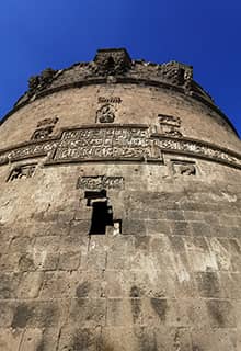
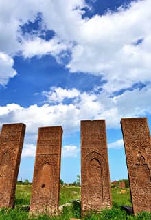
The Tombstones of Ahlat the Urartian and Ottoman Citadel, Bitlis
UNESCO World Heritage Tentative List 2000
Ahlat is located 50 km from Bitlis, at the edge of the biggest lake in Türkiye, Lake Van, with spectacular scenery. The history of the city dates back to 900 BC, to the Urartian period; however, the famous tombstones here are from the 12th to 15th centuries. The tombstones belong to the Seljuk period and the most important ones are in Harabe şehir cemetery; Taht'ı Suleyman cemetery; Kırklar cemetery; Kale cemetery; Merkez cemetery; and Meydanlık cemetery.
Seljuk Caravanserais on the Route from Denizli to Dogubeyazit
UNESCO World Heritage Tentative List 2000
When the Seljuk Turks arrived in Anatolia, they found a land with no central authority to protect the trade routes. Among the first things they did, was to repair the old Roman road network, repair the bridges, and build caravanserais along these routes to serve and protect the caravans. Depending on the topography, usually every 20-25 km a caravanserai was built. In mountainous parts, this distance would drop to 8-10 km - the distance a caravan could cover in a day. These caravans were protected by Seljuk soldiers, and at night, accommodation, food, and protection was provided at the caravanserai. Along the main trading routes there are still several caravanserais that are preserved in excellent condition. Along the Denizli-Doğubeyazıt route there were about 40 caravanserais; 10 of these are in a very good condition. These include Akhan, Ertokuş Han, Saadettin Han, Obruk Han, Ağzikarahan, Sultan Han, Oresin Han, Sikre Han, Mama Hatun Caravanserai and Hacibekir Han.
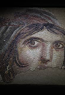
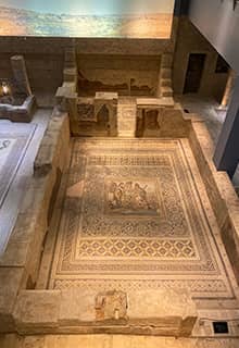
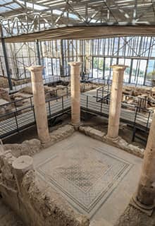
Archeological Site of Zeugma, Gaziantep
UNESCO World Heritage Tentative List 2012
The ancient site of Zeugma was once an important city of the Kingdom of Commagene. It is situated approximately 50 km east of Gaziantep, on the banks of the Euphrates. Its name derives from the bridge of boats (zeugma) that in ancient times connected the riverbanks, forming one of the major river crossings of the region. A significant part of the archaeological site is now lost under the waters of the Birecik Dam. However, its most spectacular finds, especially the magnificent mosaics, are displayed at the Zeugma Mosaic Museum in Gaziantep. Zeugma was founded as “Seleucia” by Seleucus I Nicator, one of the generals of Alexander the Great who fought for control over his empire after his death in 323 BC. In ancient times, the name “Zeugma” encompassed twin cities on the banks of the Euphrates. The western town was known as “Seleucia” after the founder, while the eastern settlement was called “Apamea” after Seleucus's wife, Apama. Recent excavations by Turkish archaeologists unearthed another residential area with mosaics. The Zeugma Mosaic Museum is one of the largest mosaic museums in the world.
Yesemek Quarry and Sculpture Workshop, Gaziantep
UNESCO World Heritage Tentative List 2012
Yesemek is an open-air museum and archaeological site located on the Syrian border, 200 km east of Adana on the way to Gaziantep. The site was a Hittite stonemasonry workshop and contains precious sculptural material. Between the 2nd millennium and the 8th century BC, Yesemek was the largest stone quarry and sculpture workshop in the Near East. Then, time stood still until 1890 when ruins were partially unearthed by an Austrian archaeologist. Today, the site is an open-air museum with nearly 300 pieces of unearthed statues. The majority of these are parts of sphinxes and lions.
Zeynel Abidin Mosque Complex and Mor Yakup (Saint Jacob) Church, Mardin
UNESCO World Heritage Tentative List 2014
The Zeynel Abidin Mosque Complex and Mor Yakup (Saint Jacob) Church are situated in Türkiye’s southeastern Mardin Province, approximately 60 km from Mardin, on the Syrian border. The mosque complex, according to an inscription, was built in AD 1159, during the Zengid dynasty, a Turkic dynasty that ruled on behalf of the Seljuks. The complex consists of a mosque, a minaret, and shrines of Zeynel Abidin and his sister Sitti Zeynep. The Mor Yakup Church (Church of Saint Jacob in Nisibis) is located 100 meters east of Zeynel Abidin Mosque. The Syriac Orthodox church is dedicated to Saint Jacob of Nisibis, and shows the signs of different civilizations from the 4th century BC onwards. The mosque and church stand next to each other, a testament to brotherhood and tolerance in Türkiye.
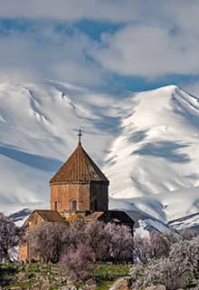
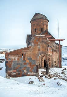
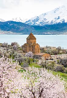
Akdamar Church, Van
UNESCO World Heritage Tentative List 2015
The Church of the Holy Cross or Akdamar Church (Akdamar Kilisesi or Surp Haç Kilisesi in Turkish) is located on Akdamar Island, the second-largest of the four islands in Lake Van. It is a medieval Armenian Apostolic cathedral, built as a palatine church for the rulers of the Kingdom of Vaspurakan. Later, it served as the seat of the Catholicosate of Aghtamar, which was an independent see of the Armenian Apostolic Church and existed for almost eight centuries.
Ismail Fakirullah Tomb and Its Light Refraction Mechanism, Siirt
UNESCO World Heritage Tentative List 2015
The Ismail Fakirullah Tomb is located in Tillo, a village near Siirt. The tomb is famous for reflecting the light at equinoxes. Using an astrolabe and a walking stick with astronomic observations, İbrahim Hakkı, a student of Ismail Fakirullah, managed to build a mechanism by correctly positioning the stones on the wall of the tomb. He succeeded in letting the sunlight into the cenotaph on the two equinoxes while the rest of the town was more or less covered in darkness. The tomb consists of two rooms and a hallway covered by one large and two small domes and a tower. The tomb has a square plan covered by a dome. The transition to the dome is through squinches. There are two-level windows on all the façades of the structure.
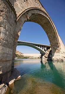
Malabadi Bridge, Diyarbakir
UNESCO World Heritage Tentative List 2016
The Malabadi Bridge is located on the Silvan-Diyarbakir road and was built in the 12th century AD during the Artuqid period. The arch bridge extends across the Batman River, a major tributary of the Tigris, and is the longest-spanned stone arch bridge in the world. Its pointed arch is 40.86 m tall.
Tushpa/Van Fortress, the Mound and the Old City of Van, Van
UNESCO World Heritage Tentative List 2016
Tushpa was the 9th-century BC capital of the Urartians, which later became the modern city of Van. The name “Van” derived from “Biainili,” the native name of Urartu. The ancient ruins are located just west of Van and east of Lake Van. Urartians were a people who lived in the same period as the Phrygians and created perhaps the most important civilization of Eastern Türkiye in this period. There has been speculation that the Urartian language perhaps was an early form of Armenian; however, linguistically, there is no connection between the two. The fortress is located on the southern shore of Lake Van. To its north, in the same direction, lies the Mound of Van Fortress and to its south the Old City of Van. Excavations at the mound have revealed 5,000 years of old settlement culture, while excavations in the Old City have revealed 800 years of urban life. The site has been occupied from the third millennium BC to the beginning of the 12th century preserving an incredible wealth of humankind’s history.
Karatepe-Aslantaş Archaeological Site, Osmaniye
UNESCO World Heritage Tentative List 2020
The Karatepe-Aslantaş archaeological site is situated within the Karatepe-Aslantaş National Park, which is approximately 130 km northeast of Adana. The site is on top of Karatepe, on the west bank of the Aslantaş dam lake. The citadel towers over the hinterland of urban centers in the Cilician plain, the Cilicia Pedias of antiquity, known for its abundance. The fortress dates back to the late 8th or early 7th century BC. Karatepe-Aslantaş is one of the most recent archaeological sites where Luwian language inscriptions have been discovered. In the 12th century, the Hittite Empire had collapsed and left behind a series of smaller kingdoms, scattered in the area of southeastern Asia Minor, mainly around Gaziantep, Malatya, and Osmaniye. Thanks to the work of Turkish archaeologists, almost all the artifacts, stone statues, reliefs, and inscriptions have been preserved and left in their original place.
Historic City of Harput, Elazig
UNESCO World Heritage Tentative List 2018
The Underground Water Structures in Gaziantep; Livas' and Kastels
UNESCO World Heritage Tentative List 2018
Zerzevan Castle and Mithraeum, Diyarbakir
UNESCO World Heritage Tentative List 2020
Gastronomy, Gaziantep
UNESCO Creative Cities Network
Gaziantep stands out as one of the world's most important gastronomic cities. It has been included in the UNESCO Creative Cities Network since 2015, as the first gastronomy city of Türkiye. Located southeast of the Anatolia Region in Türkiye, Gaziantep is well-known for its long gastronomic history which has been at the core of its cultural identity since the Iron Age. Nowadays, gastronomy remains the main driving force of the local economy. In a city of 1,890,000 inhabitants, 60% of the active population is employed by the sector, and a significant 49% of the enterprises are mainly dedicated to food, including spices, cereals and dried fruits, its world-famous baklava, and pistachio and kebab culture. In Gaziantep, gastronomy is synonymous with festivities, intercultural dialogue, and social cohesion. The Gaziantep Pistachio Culture and Art Festival, and the International GastroAntep Festival have livened up the city and stand as flagship events with their wide range of performances combining gastronomy, music, literature, and folk art. Other local festivals include the Shira Festival, which is a unique 3-day event that brings together the entire city in order to share the diversity of local cuisines inherited from Gaziantep’s location on the ancient Silk Road. The city takes advantage of this distinguished geo-cultural location to enhance cooperation with sister cities, notably at the Silk Road Mayors Forum which aims to foster the development of sustainable cities by tackling poverty and environmental issues.
Music, Şanlıurfa
UNESCO Creative Cities Network
The UNESCO Creative Cities Network is a global initiative that recognizes and celebrates cities for their commitment to fostering creativity and promoting cultural industries. These cities are categorized into seven creative fields, including music. In a recent development, Şanlıurfa was admitted as a Music City within this prestigious network. This acknowledgement highlights Şanlıurfa's rich musical heritage and its dedication to nurturing the art of music. The city's vibrant music scene, diverse musical traditions, and the efforts of its residents to preserve and promote musical culture have earned it a well-deserved place within the UNESCO Creative Cities Network as a Music City. This recognition not only showcases Şanlıurfa's commitment to cultural diversity but also offers the city the opportunity to collaborate with other music cities worldwide, fostering the exchange of knowledge and artistic innovation.